Costa News Spain Breaking News | English News in Spain.

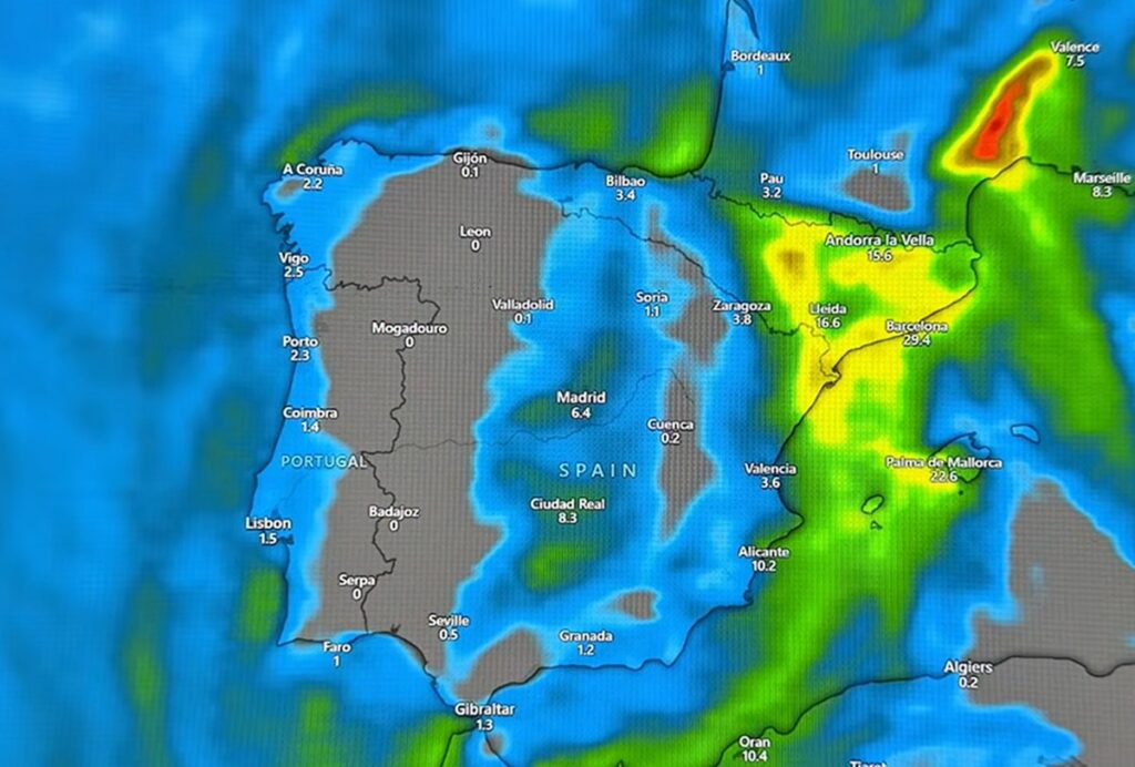
Forecast map showing heavier rainfall expected in eastern Spain and the Balearic Islands.
Credit : Youtube – Jorge Rey
Spain is heading into a spell of weather that is likely to catch many people off guard. After days of unsettled conditions, forecasters now warn that things are about to turn rougher, with heavy rain, falling temperatures and the growing risk of snow in several parts of the country.
The State Meteorological Agency (AEMET) has already confirmed the arrival of a train of Atlantic fronts that will sweep across the peninsula over the coming days. These systems are expected to bring widespread rainfall, affecting much of Spain from west to east.
But according to some forecasts, the worst may still be to come. Weather commentator Jorge Rey is warning that a new DANA could arrive next week, triggering a fresh round of storms and snowfall that may significantly disrupt conditions across several regions.
Rain spreads across Spain as Atlantic fronts move in
For the rest of this week, the weather will remain unsettled in many areas. A first Atlantic front is expected to bring rain to parts of western Spain, while a low-pressure system forecast for Friday could extend wet conditions across much of the country.
Eastern regions are also likely to feel the impact, with heavy rain expected in parts of the Levante as the system settles. By Saturday, rainfall is forecast to continue in areas such as Aragon and Catalonia, where conditions may remain gloomy and damp.
Snow is expected during this period, but mainly in mountainous areas, including parts of Soria and Teruel. For now, forecasters say accumulations should be limited and of little significance, at least until colder air moves in.
Despite this, meteorologists are keeping a close eye on how the situation evolves, as changes in air mass could quickly alter snow levels.
Jorge Rey warns of storms and snow next week
Looking further ahead, Jorge Rey believes Spain is on the verge of a more dramatic shift. In a video published on YouTube in recent hours, he says that a new weather system is forming and could arrive next week, bringing with it polar maritime air, increased humidity and unstable conditions.
According to Rey, this combination could lead to strong storms and heavier snowfall, particularly from the middle of the week onwards. He suggests that snowfall chances will rise noticeably from Thursday, especially in inland areas such as Soria, as well as in higher parts of Granada.
Rainfall is also expected to intensify in regions including Catalonia and Valencia, where several cities could see prolonged periods of wet weather if the DANA develops as expected.
Rey had already warned earlier in the week that poor weather was on the way, and his latest update reinforces the idea that Spain’s wintry episode is far from over.
Who is Jorge Rey and why his forecasts attract attention
Although not an official meteorologist, Jorge Rey has become a familiar name to many Spaniards. The 18-year-old, from a small village in the province of Burgos, rose to prominence after accurately predicting the arrival of Storm Filomena in 2021.
His forecasts are based on las cabañuelas, a traditional method rooted in observation and long-standing rural knowledge. Since Filomena, Rey has built a large following on social media, where he regularly shares his weather predictions.
While experts are careful to stress that traditional methods should not replace scientific forecasting, Rey’s growing audience shows that many people are keen to hear his take – especially when his warnings align with those of AEMET, as they appear to do now.
Temperatures set to fall sharply this weekend
AEMET spokesperson Rubén del Campo has also warned that temperatures are expected to drop noticeably as the week progresses. He says it is “likely that a low-pressure system accompanied by cold air will reach Spain”, leading to snowfall, frost and widespread precipitation, particularly over the weekend.
Maximum temperatures are forecast to stay below 10°C across much of the country, with milder conditions mainly limited to coastal areas. Inland regions, especially in the north and central parts of the peninsula, could see widespread frosts, adding to the wintry feel.
Snowfall cannot be ruled out at lower altitudes, particularly on Saturday and Sunday, depending on how the cold air mass develops.
With rain already soaking large areas and colder weather on the way, authorities are urging people to stay informed, take extra care on the roads and be prepared for rapidly changing conditions.
As Spain braces itself for this unsettled period, one thing is clear: winter is making itself felt again, and the coming days could bring some surprising – and challenging – weather.