Costa News Spain Breaking News | English News in Spain.


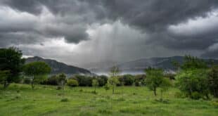
Forecasts predict a polar vortex will bring rain, wind, and colder weather to northern Spain over the weekend.
Credit : Screenshot- Tiempo.com
Think again if you thought Spain was finally settling into a relaxed rhythm by the end of November. Meteorologists have warned that this weekend a new blast Arctic air will hit the country, bringing with it freezing temperatures, widespread rain, and the return to snow at low elevations.
This Friday, November 28 may feel calm enough – stable skies and crisp cold mornings with minimums of –2ºC in places like Albacete, León, Lleida, Palencia and Valladolid – but it’s simply the quiet before a much sharper change. According to the State Meteorological AgencyAemetForecasts and forecasts for eltiempo.esFrom Saturday onwards, a shift in the polar Jet Stream will cause a sudden cold front to sweep across the country, bringing an end to November that is dramatic.
Rain in the half of the country on Saturday, the day after the Arctic air
Rain linked to an approaching front is expected to reach Galicia overnight and Saturday, November 29, the first signs of a change. By early morning, another colder front sweeps in from the northwest, helping to intensify the rainfall – particularly along the Atlantic coastline, where showers are expected to be frequent and persistent.
The band of rain will spread further inland as the day progresses. Extremadura, Castilla y León, Asturias and Cantabria will be next in line, before the front continues its march eastward and reaches parts of the Basque Country, Navarra, La Rioja, Madrid and Castilla-La Mancha by the end of the day.
Forecasters warn of heavier rains in Galicia and Cantabrian areas.
The temperature will behave in a somewhat unusual way. Minimums will increase in the Northwest, cushioned slightly by clouds and wind. In the Southeast, temperatures will creep up just a little. For the rest of the nation, however, the night’s temperatures will remain the same as they were on Friday.
The cold will be more intense during the day. Maximum temperatures are expected to drop between 1ºC and 3ºC across large areas of the west and centre. To give an idea, León may reach only 7ºC, Madrid will hover around 12ºC, while southern regions like Seville or Málaga will hold onto highs above 18ºC, at least for now.
On Sunday, the front pushing east will cause snow to fall up to 1,000 metres.
By Sunday, the front will have advanced further across Spain, leaving a trail of weaker but still widespread rain across Andalucía, Murcia, the Valencian Community, the Balearics, Catalonia and Aragón.
As the cold air filters in behind the front, snow levels drop to: As cooler air filters behind the front, snow levels drop to:
- Cantabrian mountain range: 1,100 m
- 1000 metres in the Pyrenees.
- The Central and Iberian Systems have a total of 1,200 metres.
The first snowfalls in the mountains will not be everywhere. But it is a good day to get into the winter mood.
The showers in Spain will be more intense and persistent to the east and Basque regions.
Sunday’s temperature pattern will also flip again: the minimums will rise in many inland areas because of thicker cloud and stronger winds – limiting frost – while the maximums will fall almost everywhere, dropping between 2ºC and 4ºC.
Canary Islands are on a totally different script. The archipelago is expected to enjoy stable weather until the end of November. Only a few light showers are possible on the northern slopes.
Jetstream active until early December: More rain to come
Forecasters warn that a calm start to December is unlikely. Meteored reports that the polar jetstream is strengthening. It has moved slightly north, but it still shows the type of undulations which allow cold air troughs to reach Spain.
Both European and American Forecasting Models suggest:
- Before the long weekend in December, several more Atlantic fronts may arrive.
- The temperature may fluctuate between cold and warm temperatures.
- Rain will continue to fall, particularly in the Northwest.
- Mediterranean showers could return if one of the troughs dips further south – something still being monitored.
Spain has a classic winter pattern heading into December: active, variable and never dull.