Costa News Spain Breaking News | English News in Spain.

Privacy and safety concerns have been raised by a live map showing the locations of V16 emergency beacons in Spain.
Credit: Screenshot from mapabalizasv16.es
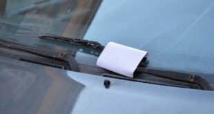
The V16 emergency beacon in Spain was intended to be a simple upgrade for many drivers. Switch it on when you breakdown, to alert other road-users automatically and avoid stepping in live traffic. Simple enough.
Things haven’t gone quite as planned.
In recent times, a newly created private online map showing the real-time location of activated V16 beacons has started circulating online – and it has raised more than a few eyebrows. The map is based on data linked to DGT, and anyone can zoom into any town, motorway, or rural road to see if a beacon is active. This includes the length of road as well as the time that it was supposed to switch on.
It seems like a clever piece of technology at first. When you look a little more closely, some drivers begin to feel uneasy. What stops the wrong people, if anyone can find out where vehicles are stranded?
After television reporters discovered a more puzzling phenomenon, concerns have grown.
If the map shows that a beacon was not switched on
A team of Antena 3’s programme Y ahora Sonsoles The map was tested by the group. They saw several beacons clustered together within a distance of 20 kilometers and decided to go out on the ground to see for themselves what was going on.
The first stop was a car parked on the road. When the reporter asked the driver if he knew how the map had located him so quickly, he admitted he was familiar with the system – but hadn’t even had time to take the beacon out of the car yet. His vehicle had already been spotted online.
The second marker led the team to a road that was empty. The team found no visible incident. No car was broken down, there were no flashing lights, nothing. The third point brought them to another lorry with its hazard light on but no V16 beacon. In a third case, the driver claimed to own the device but had not even opened the box.
This left many people puzzled. How can a place appear on a map if the beacon isn’t on?
The social media was quickly filled with rumors. Some motorists became concerned that the devices could be transmitting continuously. Others joked nervously about wrapping their beacon in aluminium foil just in case – half humour, half genuine concern.
This kind of visibility in the real-world is much more concerning. A map of stranded vehicles on the internet could be used by scammers and fake recovery trucks to take advantage of drivers who are already under stress.
Experts in cybersecurity explain what could really be happening
To clear up the confusion, the programme spoke to cybersecurity expert Miguel López. He began by calming some fears. No personal data are shared and the system does not track individuals. What is visible is the location of a vehicle linked to a traffic accident.
But López also acknowledged that making this type of information so accessible can create opportunities for abuse. Criminals could be able to easily identify where vehicles have been stopped. This would make it easier for them to plan certain scams.
Many people have missed the fact that this map is not an official DGT Platform. The map was created by an individual who used traffic data. It is important to know this because the map might be mixing up different sources of traffic data.
According to López, the V16 beacon cannot transmit anything unless a driver actively switches it on. If you see vehicles on the map but no beacon appears, it is likely that the DGT is using the map to display other types incidents, like reports from traffic camera or patrols.
The beacon is not likely to be broadcasting the location of anyone secretly. The confusion appears to be in the way data is interpreted and presented.
The incident has, however, added a new layer of doubts to a device which has already been the subject of much debate since it became mandatory at the beginning of the year. Many drivers feel uncertain about the technology, how it works, and what data is shared.
López also pointed out that similar location data has existed for years through navigation apps and traffic monitoring systems. What’s different is the visibility. When information becomes easily searchable on a public map, people naturally pay more attention to it — and sometimes imagine worst-case scenarios.
Practically speaking, this is a simple lesson for drivers. It’s important to be cautious and confirm who is offering assistance if you are stranded. This was the case before V16. When possible, use official recovery services and avoid giving out personal details on the roadside.
The V16 was intended to increase safety and reduce risks on Spain’s highways. This latest story demonstrates that even technology which is sensible can be a source of anxiety when it comes to everyday reality. Many motorists have yet to get used to the fact that a small blinking light can be far more important than they thought.