Costa News Spain Breaking News | English News in Spain.


Wind, rain and 10ºC drop in temperatures in Spain.
Credit: Kate Liland Shutterstock
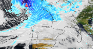
Spain’s heatwave of late August is changing to something less calm this weekend. A deep low-pressure area in the North Atlantic is currently intensifying northwest of the Azores and looks to be affecting conditions on the Iberian Peninsula. Forecasters believe it could be one of the most severe storms in recent memory. the deepest low-pressure episodes recorded in any AugustIt would be named Vitor by the Southwest European Meteorological Group. It is being monitored by the US National Hurricane Center for any subtropical features that may develop as it moves east-southeast toward Portugal and Spain.
Between Friday and Saturday, the majority of deepening takes place well offshore. By the time the influence reaches the continental area, the system will have already filled. so direct extremes look limited. Still, cooler Atlantic air and moisture will filter in, especially by Sunday, August 23 with temperatures expected to drop in places 10ºC.
Temperatures begin to decrease across Spain
You can expect a drop from the sticky heat of recent days. Most areas will remain a few degrees cooler than the normal late-August temperatures. The southern and western regions will still be pleasantly warm with temperatures in the low to mid 30s Celsius. Northern and northeastern areas are cooler. Nearly everywhere, nights will feel more refreshing after a recent spate of hot evenings.
🍂 ¿Estamos ante la llegada definitiva del tiempo otoñal? 👉 Aún habrá un nuevo repunte térmico.
— Meteored España (@MeteoredES) August 20, 2026
Rain, wind, and storms are mainly in the northeast
The weekend looks quiet in most parts of the country. Only scattered showers are possible. Sunday will be the day when things become more clear. The main local risk is strong thunderstorms and showers across the northeastern part of the peninsula, including the Valencian Community. Catalonia, eastern Aragon, and northern Valencia are at risk. highest chance of intense downpoursSome could be persistent and heavy. A moist easterly wind may also push rainbands into areas facing the Mediterranean.
The wind will be moderate in general, but gustier conditions may occur near storm cells. Balearics may see an earlier period of strong activity subside, resulting in more scattered showers. Conditions are mostly settled in the south and west including Andalucia, the Costa del Sol and much of Andalucia. There is plenty of sunshine, but no intense heat.
What it means for popular destinations
Once any remaining cloud has cleared, the Costa del Sol will enjoy a weekend with plenty of sunshine and pleasant temperatures. Costa Blanca, Murcia and the rest of Andalucia will have a mixed weekend. The weather is expected to be mostly sunny, but there’s a chance that storms will develop inland in the afternoon on Sunday.
Barcelona and the Catalan Coast are at higher risk for rain and thunder, especially later in the weekend. The towns in the north of France should be prepared for a changeable and cooler climate.
In recent weeks, it has been shown that storm cells can quickly form following heat waves. If you are planning to go outdoors or have travel plans booked, check your local warnings.
Shortly, the Atlantic low will bring a taste of autumn in early rather than a full blown battering. In the coming days, expect cooler air in the east and the possibility for showers. Take advantage of the weather as it could return next week.
La borrasca que se aproxima será subtropical
A partir del fin de semana se formará una borrasca entre #Azores You can also find out more about y #Portugal que tendrá unas características especiales para nuestras latitudes (aunque puntualmente no es del todo raro en los últimos años). Su núcleo será cálido, a… pic.twitter.com/icySzVviS6
— MeteoBrais (@MeteoBrais1) August 20, 2026