Costa News Spain Breaking News | English News in Spain.


Spain has already been hit by its first winter storm this week. According to the forecast by the Spanish state meteorological agency, the entry of an arctic mass of air has already caused temperatures in 14 provinces to drop.
Aemet warns of a “drop in temperatures over the next few days” in Andalucía. “Friday and Saturday will be the coolest days for Andalucia. The temperatures will begin to improve on Sunday. This week, there won’t be much rain,” reads the summary posted on X.
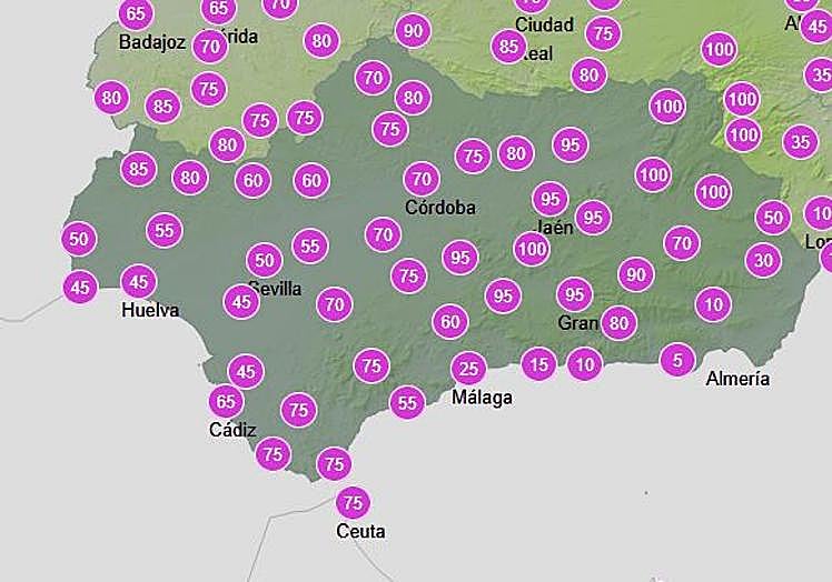
A new rainstorm is forecast for the region starting at noon on Monday 24th of November. The probability of showers will exceed 65% in Cadiz, Cordoba, Jaén and Granada. Seville will have a 50% chance of rain, Huelva 45%, and Malaga 25%. Almeria will be the only place where there is no chance of rain. The interior of Jaén and Granada, together with the Sierra de Aracena area in Huelva, are the places most likely to receive rainfall.
Rainfall probability on Monday in Andalucía, according to Aemet.
Aemet
Cadiz, Almeria and Cordoba will all have temperatures above 6C on Monday. Almeria will have a minimum temperature of 13-14C, while Malaga and Cadiz are expected to be slightly warmer.
On Tuesday, Aemet is increasing the probability of showers to 70% until midday, especially between 6am and 12pm in Jaén, Granada, Cadiz and Cordoba. Rainfall probability will fall below 20% after 6pm.