Costa News Spain Breaking News | English News in Spain.

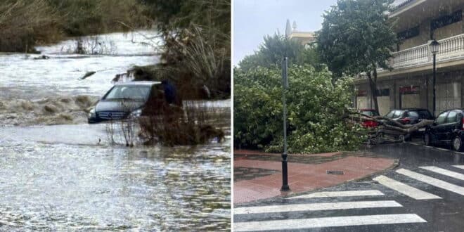
Spain is currently experiencing continuous heavy rains, strong wind, and widespread alerts for weather due to Storm Joseph. A deep low pressure system, its unusual behaviour has been so prolonged because of a rare Fujiwhara effect.
This unusual phenomenon is a combination of a powerful atmosphere river and intense precipitation. It keeps intense rain locked over many regions. This increases the risks of flooding, overflowing rivers, disruptions and leads to AEMET orange alerts In many parts of the country, there are high winds. Emergency services have closed schools, blocked provincial roads and bridges, and made it dangerous to walk in the streets. A 31-year old woman died after a palm was uprooted by high winds in Torremolinos, Spain, on Tuesday.
What is the Fujiwhara Effect? And how does it impact Storm Joseph?
When two or more low-pressure systems collide with each other, they can cause them to orbit one another or slow down significantly. Storm Joseph, which is capable of dumping intense rainbands, interacts with another nearby area. This is a good example. interaction Storms become stationary or move slowly, as they feed on the moist Atlantic air. They also regenerate rain fronts.
The result is a continuous rain over the same area, rather than a system that moves quickly. Experts claim that this effect was especially active between Tuesday and Wednesday night, leading to hours-long downpours. The storm has been intensified by the unusual dynamic, which makes it difficult for the system’s dissipation or to move away from Spain.
Credit: IPMA
Atmospheric River powers continuous heavy rainfall
A potent additive can be used to increase the intensity. atmospheric riverA narrow, but highly moist airflow that originates from the subtropical or tropical regions and crosses over the Atlantic. These structures are described as “motorways for humidity” and transport huge amounts of water vapour over the oceans. The river adds to Joseph’s fronts and the associated fronts. This causes highly efficient condensation as the moisture collides with storm systems and Spain’s terrain.
Meteorologists claim that this mechanism is critical to the episode’s size, causing persistent heavy rain and very high accumulations for extended periods. Galicia and northwest peninsula are particularly vulnerable because soils and rivers have already been saturated by previous days of rain.
National alerts for rain, wind and coastal perils
The Spanish State Meteorological Agency, Aemet, has issued alerts All autonomous communities will be affected by multiple hazards this Wednesday, January 28, 2019. Andalucia is still under a rain alert, as are Castilla La Mancha and Catalonia. Wind alerts cover Madrid, Murcia and Comunitat Valenciana.
Snow alerts are in place in Aragon, Castilla y Leon, Castilla-La Mancha, Extremadura, Catalonia, Galicia, Comunidad de Madrid, Navarra, and La Rioja. Andalucia covers Asturias and Baleares. Cantabria includes Catalonia. Murcia is also covered.
Combining factors can increase the danger of flooding, rivers breaking their banks and falling trees and branches. Infrastructure damage is also increased. Experts warn the primary danger lies in the length of the extreme weather episode. A saturated ground can lead to more runoff, and flash flooding.
Forecasters warn that the pattern of Storm Joseph will continue to be unsettled. They urge residents to stay up-to-date with weather forecasts and to avoid unnecessary travel to affected areas.