Costa News Spain Breaking News | English News in Spain.


Asturias, and other nearby areas may see locally intense rains. High-resolution models predict that accumulations can reach 30 litres/square metre over dangerously brief periods. AEMET issued yellow warnings in Asturias. Recently, storms in the east have also caused some disruption, such as a supercell near Tarragona.
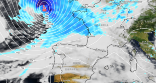
Conditions in the northwestern areas should ease over night, but this will only be a temporary respite. From midweek, a deeper change will occur as fronts of the Atlantic and lines linked to a low-pressure system are more likely to spread rain and thunderstorms. A cooler polar airmass will also push temperatures down in the peninsula, causing a drop that is more similar to early autumn rather than late August.
Rain and thunderstorms are more frequent in the middle of the week
Between Wednesday and Thursday, the intensity and reach of instability is expected to increase. There will be several fronts, and instabilities lines that cross the country. This could bring showers or thunderstorms which may turn localized strong. Northwestern and western Spain are the most vulnerable to wetter conditions, but the pattern is unsettled across the country. AEMET has already flagged the risk of intense rainfall As the system evolves, similar alerts may be expanded.
🌀 Una nueva borrasca afectará a España miércoles y jueves.
⛈️ Lluvias en el noroeste peninsular, abundantes y con tormentas fuertes en Galicia.
🌬️ Rachas de viento muy fuertes en el norte peninsular.
🌡️ Descenso térmico el jueves, pero calor en el este peninsular y Baleares. pic.twitter.com/piNKnTs5YE
— AEMET (@AEMET_Esp) August 25, 2026
The majority of readers along the south and eastern coasts, as well as the Balearics, will be able to notice the change in temperatures instead of heavy rains for the time being. In many coastal areas, daytime temperatures should be comfortable and summer-like. The Mediterranean and island regions will hold onto higher values longer than the North and West. The overnight lows are expected to feel cooler, especially in the interior of the Costas. This will be a welcome change after the recent heat.
What does the Costas/Balearics change mean?
Residents and tourists on the south and east coasts should expect largely settled or lightly changing conditions for much of the time. The sun should be out, but clouds will occasionally increase as the pattern develops. Watch the sky if you plan to be outdoors later this week. Expanding instability could bring showers and storms closer to the Mediterranean. The Balearic Islands have a similar pattern. They are generally cooler than the north of the continent, and there is only a small risk of rain.
If you’re heading west or north later this week, be sure to check the local conditions. Heavy rains and flooding may occur in those areas.
The week ahead
The west and north-west should be feeling fresher, damper and almost like autumn in some places by the end of this period. Mediterranean coast and Balearics hold on to more of that late-summer feel. While the activity in other areas is decreasing, there may be showers still occurring in the northeast. This is in line with the recent Atlantic influence which has already begun to ease the extreme heat.
In general, the South, East and Islands are experiencing milder conditions, with less disruption. However, the Northwest is suffering from the heavier rains and stormy weather pattern.