Costa News Spain Breaking News | English News in Spain.

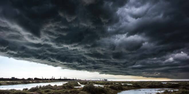
Storm Theresa creeping along the Spanish south coast.
Credit: Daniel J Skinner – Shutterstock
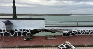
Storm Therese is barrelling towards southern Spain, bringing widespread disruption and orange-level warnings from the Agencia Estatal de Meteorología (AEMET). Forecasts include heavy rain, strong winds, rough seas, and even snow on higher ground. Canarias will be the hardest hit, while Andalucia is likely to feel the effects starting Friday. Residents of coastal and inland regions should prepare for difficult conditions in the next few days.
Who will be affected this weekend by disruption?
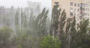
Weekend plans face major upheaval In the southern regions. Due to the heavy rains and high wind, beach trips along the Costa del Sol will be cancelled. Travel disruptions may also occur. Farmers in western Andalucia face crop damage as a result of persistent rainfall. Outdoor events in cities such as Malaga are also postponed.
Canarians have faced the worst threats up to now. This includes flash floods and power outages caused by intense storms. In the affected zones, drivers will have to drive with caution on exposed roads or mountain passes.
The exact timing of the storm’s arrival at certain locations
Storm Therese will reach Cadiz as the first of the designated areas. The storm is expected to intensify easterly wind and showers from Friday morning and peak through the afternoon and into the evening. Very strong gusts may be experienced along the coast. This is all moving up from Canary Islands where it has already left behind a frozen shock.
🌧️❄️ La borrasca Therese deja frío extremo y fuerte viento en Canarias: hasta -4,5ºC en Izaña y rachas de 88 km/h 💨 Lluvias moderadas y condiciones duras en cumbres de varias islas #Canarias #Temporal @LaRadioCanaria #TGR 📻🎙️🎥 @CabildoTenerife pic.twitter.com/quAaBGevjy
— Juanjo Toledo (@Juanjo_Toledo) March 19, 2026
- As temperatures drop, Ronda will experience heavy rains as the clouds thicken and develop during the day.
- Malaga should expect to experience effects from Friday afternoon onwards. Showers are likely, particularly after noon. Coastal warnings will be issued for wind and waves around 6pm.
- Motril in the East on the Granada Coast follows a timeline similar to Malaga. On Friday, there is a possibility of strong showers locally and rough waves during the afternoon or night.
Tracking the progress of a storm
The official channels allow citizens to monitor events easily. AEMET’s website App provides live updates, radar images and warning maps. Follow @AEMET_Esp on X Bulletins and instant alerts are available. Local media provide frequent updates, and dedicated weather apps send push notifications to alert users of orange alerts. Residents can consult municipal civil protection pages during an incident to find out what advice is applicable in their area. Localised orange warnings will be issued for road safety and traffic.
Safety advice during orange alerts
Orange alerts are a warning of a serious risk and require caution. Avoid unnecessary trips, especially in areas near rivers, barrancos and coastal zones that are prone flooding or landslides. To avoid exposure to lightning during thunderstorms or heavy rain, stay inside. Close the windows, put the laundry in and secure outdoor items that are loose against gale force winds. You should not go to beaches or rocky coasts that are prone to high waves. Avoid driving through low-lying or flooded areas. Prepare emergency supplies, such as torches and charged phones.
Long-term Easter outlook
Semana Santa 2026 arrives from 29 March (Domingo de Ramos) to 6 April (Lunes de Pascua). Early indications of a dynamic pattern from models such as ECMWF show a slight increase in the chance of an above-average rain in southeastern Spain.