Costa News Spain Breaking News | English News in Spain.

Spain barely has time to catch its breath following Storm Nils, when another dangerous storm system comes in. Storm Oriana already has heavy rain, violent wind and plunging temperature across many parts of the country. Forecasters have warned of dangerous conditions, including snowfall at low levels, through Valentine’s Day weekend.
New storm expected to affect Andalucia and the Cantabrian Coast, as well as the Pyrenees, are all part of the Andalucia region. The broadest areas of Spain’s central and southern regions On Friday and Saturday. In many areas, gusts may exceed 100 km/h and in mountainous zones they could reach up to 140 km/h. Meanwhile, an Arctic air mass will cause temperatures to drop sharply across the country.
Snow Forecasts range from 600 to 700 meters across North Spain By Saturday morning, millions of people will be moving around the country to enjoy the weekend. This could lead to dangerous road conditions and disruptions in travel.
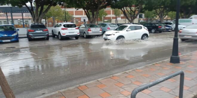
Map shows roads closed and flooded during Storm Oriana
Drivers can track the effects of Nils’ damage in real time using the interactive map of the Directorate General of Traffic. The interactive map below shows flooding, closures and accidents as the storm develops.
AENAThe company, which manages Spanish airports and helicopters, warns travelers to be aware of possible delays or cancelations due to adverse weather conditions.
Storm Oriana set to bring a rainy – and even snowy – Valentine’s Day
Forecasts predict widespread rains in Andalucia (and Galicia), along the Cantabrian coastline, the Pyrenees mountains, and across the central and south of Spain. Weather Alerts regarding strong winds and rough waves on the coasts are still active in several regions including Andalucia and the Region of Murcia.
A storm will also arrive in Spain along with an Arctic front, which will cause temperatures to drop. Snow is expected to fall in northern Spain at low altitudes (600-700 metres) on Saturday morning.
Continued strong winds on Saturday
On Saturday, there will be gusts up to 100 kilometers per hour in several regions. This includes northern and eastern Spain, as well the Balearic Islands. The Pyrenees region and provinces of Castellon or Teruel could see winds up to 140 km/h.
Snow showers are expected at lower elevations in the Cantabrian Mountains and Picos de Europa.
Oriana is expected to leave the country by Valentine’s Day’s afternoon
Storm Oriana will gradually subside by the afternoon on Saturday, February 14. However, strong gusts of wind are expected to continue throughout the day across various regions including the Balearic Islands Pyrenees region, the Emporda area and the lower Ebro Valley.
Residents are warned about a cold weekend
In the span of one night, from Saturday February 14 to Sunday February 15, frost will form in large parts of the country. This includes the north of the country, the eastern Meseta region, and some parts of Castilla La Mancha. Forecasts indicate intense frost in the Pyrenees.
Sunny Sunday?
On Sunday, February 15th, the skies should clear up, bringing relief to the entire country. The far north may still experience a few showers. The winds will decrease overnight between Saturday and Sunday. However, strong winds could persist until Sunday afternoon in mountainous regions of the Pyrenees.
Forecast for the three-day weekend: Storm Oriana in a glance
Friday, 13 February: Heavy Rainfall You can also find out more about the following: Andalucia, GaliciaAlong the Cantabrian coastThe Pyrenees. Spain’s central and south. Temperatures start to fall in many parts of the country.
Saturday, February 14, 2019 Snow Low elevations are common across the majority of the country. Strong winds Up to 100 km/h is possible in Northern and Eastern Spain In the midst of the Balearic Islands Snow and rain will begin to subside by the afternoon. However, strong winds could persist in certain areas, such as in the Balearic Islands
Sunday, February 15, 2019 Frost In many parts of the country and particularly in the The North The temperatures are soaring, and there is a lot of frost. Pyrenees region The skies will begin to clear in the afternoon. Winds are easing across the country, except for the Pyrenees.
Storm Oriana – Winter’s final hurrah!
After weeks of storms, flooding, and evacuations, the temperatures should stabilize early next week. Unprecedented winds The officials are working non-stop to clear the debris. Forecasts indicate that skies will clear and conditions should be dry for most of Spain into the next week. AEMET may be right in its forecast that Storm Oriana is the last of a series of bleak storms that has left Spain longing for sunshine.