Costa News Spain Breaking News | English News in Spain.


The third heatwave this summer will reach its peak intensity on Thursday, 23 July. Red alerts will sty active across eastern regions and parts of Andalucia, with daytime temperatures forecast to climb to 45°C in inland zones of the Valencian Community and the Region of Murcia. The overnight readings along Mediterranean coast remain oppressive. Residents and tourists have little time to recover.
Spain’s weather service AEMET continues to issue extreme heat alerts for the southern and east provinces. Interior Albacete, Guadix and Baza in Granada, inland Teruel, Murcia and northern Almeria are all set for values well above 40°C ahead of the Thursday peak. Saharan dust and light coastal breezes may reduce the highest temperatures in isolated areas, but the south-east is still under extreme heat stress.
Eastern storms will bring hail, lightning and sudden strong wind
On Wednesday afternoon and night, intense surface heating in combination with colder air at altitude will cause active thunderstorms to develop across the eastern part of the peninsula. Storms should form after midday, over the Pyrenees. They will then become more intense from 3pm. Cells are expected to track from Cuenca and Teruel in the inland towards Castellon and Murcia, and then eastwards through eastern Andalucia. A second band will affect the Huesca-Lleida Pyrenees. Be careful and be prepared for road delays if you are traveling north to France.
The storms will produce lightning and hail, which could be large in some places. They may also cause strong winds known as downbursts. The official Spanish Meteorological Office, AEMET has issued warnings Covering the Pyrenees, Huesca, Lleida, Tarragona’s pre-coastal strip and the inland areas of Castellon, Valencia, Teruel and Albacete. Also, eastern Andalucia including the Almanzora Valley, and Los Velez. Storm activity will peak between 6pm-8pm, before fading from the south. The Pyrenees and Ebro Valley are the most affected.
⛈️ Las tormentas crecerán con fuerza esta tarde en amplias zonas de tercio este peninsular.
🌩️ Irán acompañadas de gran cantidad de aparato eléctrico y de posibles reventones.
— Meteored España (@MeteoredES) July 22, 2026
There have been delays in airport operations across the east due to storm cells that formed earlier. Further disruptions are possible if heavy thunderstorms form later today.
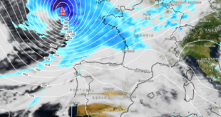
Polar air is expected to arrive on July 25th, which will help cool down the heat.
The heatwave will be tempered by cooler Atlantic air that begins to influence the north-west on Friday. It then spreads south-eastwards through the weekend. The arrival of polar air around July 25 will bring a temperature drop, and more thunderstorms in northern areas. Sunday morning could bring readings of 10-12°C in several inland northern and central cities, including Avila, Burgos, Cuenca, Leon, Palencia, Salamanca, Segovia and Soria.
South-east coastal locations will cool more gradually, with overnight lows still near 24-25°C in Alicante, Almeria, Malaga and Murcia. Daytime maximums on Saturday may still approach 40°C in Murcia before falling more clearly early next week.
⛈️⚠️ Fin de semana con riesgo de tormentas de alto impacto en varias zonas de España.
— Meteored España (@MeteoredES) July 21, 2026
Enjoy the respite as long as you can
This cooler interlude is brief. This cooler interlude appears to be brief. Monday temperatures are forecast to rise again The south-east continues its gradual easing. The majority of model guidance indicates that a new hot spell will develop from Tuesday next week onwards, with the South and South-east once again being most exposed. The dominant pattern is a high-pressure rebuilding with another warm feed coming from North Africa.
Heat precautions are important for holidaymakers in Spain and those preparing to visit, especially around midday. This is also true for vulnerable groups. Keep hydrated and limit outdoor activities during the hotter hours. Also, follow local weather warnings regarding extreme heat or sudden severe storms.