Costa News Spain Breaking News | English News in Spain.

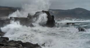
Storm Goretti bringing wind, rain and rough waves to Spain on Monday January 8.
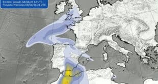
Credit X – Aemet
You can rejoice if you have been counting the minutes until the cold winter weather finally lifts. Temperatures are rising in many parts of Spain. The nights will be less icy and the mornings a bit kinder. And the worst frost will gradually retreat to higher ground.
Don’t throw away your winter coat just yet.
The milder weather is accompanied by Storm Goretti. Aemet predicts a mix of strong wind, heavy rain and snow, depending on the region. This is one of those weeks when the weather forecast becomes a part of daily conversations.
The short answer is: less cold and more chaos.
On Thursday, January 8, temperatures are rising across the Balearic Islands and the mainland. The greatest temperature rise will take place overnight when the minimum temperatures finally start to rise after a string of freezing mornings. Frost will be confined to the Pyrenees and higher areas of the inland, but some mild freezing may persist.
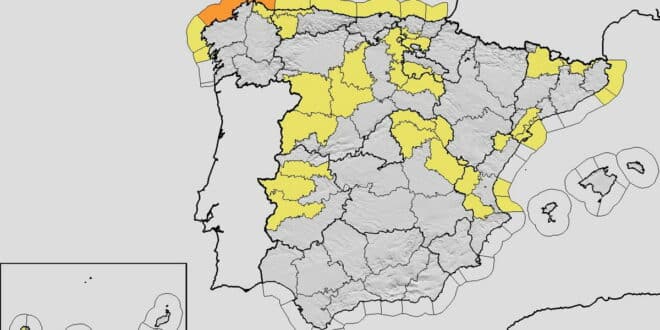
The weather warnings were activated in up to 18 provinces at the same moment, which is a sign that Goretti won’t be coming quietly.
North Spain and Canaries are on alert due to strong winds and rough seas
The wind is the main feature of this new weather pattern. Aemet Warnings are being issued for very strong gusts of wind in Galicia and along the Cantabrian Coast, as well as across mountainous areas of the northern third. Areas exposed along the east side of the peninsula, as well as parts of Mediterranean coast, could feel the brunt.
Among the places most likely to notice the change are Asturias, Burgos, Tarragona, Lugo and Castellón, as well as several Canary Islands, including Tenerife, La Palma and Gran Canaria. Residents in these regions may experience anything from rattling windows and difficult driving conditions to ferry delays and rough crossings.
Even the sea is not spared. Significant waves are expected along much of the northern coastline, with an orange warning active on parts of the A Coruña coast and yellow alerts elsewhere along the Cantabrian and Mediterranean shores. Rethink coastal walks, fishing trips and outings in small boats.
While none of this is unusual for winter, the timing – arriving just as the cold eases – can catch people off guard. A mild day doesn’t necessarily mean calm weather.
Rain is coming from the west while the snow reaches higher in the mountains
Galicia is likely to be hardest hit by the rain as fronts connected to Goretti move northward. Locally heavy and persistent rain is predicted, especially for the western half, where the wet spells may last several hours.
There will be frequent showers along the Cantabrian Coast and in the Pyrenees. In other parts of northwest, there may be more scattered rainfall. The skies are expected to remain cloudy in other parts of France, but the Mediterranean Coast and the extreme southeast will likely escape the worst rain.
Snow hasn’t disappeared – it’s simply being pushed uphill. As the temperatures rise, snow lines will steadily climb. The snow line will start at 1,400 to 1,600 meters in the northern mountains and then rise to 1,800-2,200 metres by weekend. In the western Pyrenees, snow accumulations may be notable at high altitudes. Other ranges are likely to keep snow confined to their highest peaks.
It could be a mixed bag for ski resorts. The higher slopes will benefit but the lower areas may see more rain than snow.
Weekend outlook: clouds, wind, and another wet weekend for Galicia
On Friday January 9, the unrest will continue. Along the Cantabrian coastline and in exposed regions of the northeast, Ebro Valley and the Balearic Islands, strong winds will persist. Some parts of the southern plateau could also be affected by stubborn fog that can make driving difficult at first light.
Heading into the weekend, the atmosphere calms slightly – but only slightly. Saturday 10 January should bring modest improvements from the southwest to the northeast. Cloud cover will still be widespread. The Cantabrian coast will continue receiving rain, as well as the western Pyrenees. Showers could still persist.
Sunday looks to be the wettest of the weekend. Forecasts indicate more rain in the Northwest, and Galicia is once again at the front line. It will fill reservoirs and make the countryside greener, but may also result in soggy conditions for travel and changes made to outdoor plans.
The upside? Overnight temperatures are expected to be relatively mild. For many parts of Spain, this will mean fewer frozen windscreens in the morning and a more comfortable start to the day – even if an umbrella remains close at hand.
Overall, Spain is headed into a classic winter-weather trade-off. The cold will loosen its grip but the weather will become more unsettling. If you are planning to commute, travel, go into the mountains, or just plan a weekend hike, keep an eye on short-term weather forecasts and local alerts.
Storm Goretti will make sure that winter is still present, even though the frost has faded.