Costa News Spain Breaking News | English News in Spain.


Photo credit: Bakusova/Shutterstock Photo credit: Bakusova/Shutterstock
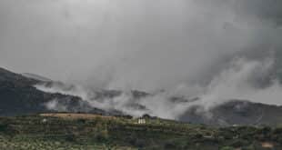
Spain is currently experiencing another weekend with unpredictable winter weather. There has only been a small pause of rain in some places. The State Meteorological Agency (AEMET) Multiple alerts have been issued as wind, snow and rough waters continue to affect large portions of the nation. Galicia is the worst affected of 11 autonomous communities.
After six powerful storms passed through the country in January, many parts of the country have experienced prolonged cloudy, rainy weather, which has limited sunlight. While the rainfall may decrease temporarily, forecasters warn that dangerous weather conditions, such as high winds, snowfall in higher elevations and hazardous waves, will continue.
Strong Wind Warnings in Several Regions
AEMET has placed Andalucía, the Balearic Islands, Castilla-La Mancha, Catalonia, and the Valencian Community under orange wind warnings, with gusts expected to reach 90–100 km/h. Meanwhile, Aragon, Cantabria, Castilla y León, Madrid, Murcia, the Basque Country, and Melilla are under yellow alerts, with wind speeds anticipated between 70–80 km/h. Residents are advised not to leave loose items unattended, to limit outdoor activity, and to take precautions when traveling.
Snow and Frost in Elevated Areas
Snowfall warnings cover Aragon, Castilla y León, Catalonia, Galicia, Madrid, and Navarra. In northern and mountainous regions, snow is expected at altitudes of 700–1,000 metres, with accumulations higher in the upper slopes. By the end of the day, snow levels are forecast to rise to 1,200–1,400 metres. The higher areas of Mallorca may even see snow on the Balearic Islands.
In the Pyrenees, moderate frost is forecast. Travel in the mountains will be hazardous for those vehicles that are not equipped for snow or ice.
Rainfall and Thunderstorms
Rain will be expected in the northern third part of Spain. This could include isolated thunderstorms or small hail. The central plateau of Spain, the Balearic Islands and mountainous areas in the southeast may also experience localized precipitation. The highest rainfall totals are expected in the eastern Cantabrian region, western Pyrenees, and eastern Bética ( Granada and Almería mountain range).
On the Balearic Islands storms can occur in the early morning hours and create temporary hazards for outdoor activities. The overall rainfall intensity will be lower than earlier this week but localised showers could still cause problems.
Hazards of the Coastal and Maritime Environment
Alerts are in place for coastal areas and the autonomous city Ceuta due to high seas and dangerous wave heights. Galicia has a red alert in the morning, when waves could reach nine metres. The warning then changes to orange throughout the rest of the day. Other coasts in the north and west remain under yellow alerts. Civil Protection authorities are urging residents to avoid beaches and docks as well as exposed coastal areas.
Combining strong winds with high sea levels increases the risk of coastal flooding and debris falling, as well as damage to infrastructure. In affected areas, maritime and fishing activities are temporarily restricted to protect personnel and vessel.
Regional Impacts and Safety measures
Authorities in the entire country are taking precautions. Emergency services in Galicia have reported fallen trees, localised floods, and disruptions to transport. Balearic Islands outdoor facilities have been temporarily closed, especially those in storm-prone regions.
Local councils in mainland areas with orange wind warnings such as Valencia and Castilla La Mancha have suspended outdoor events and sporting activities. Civil protection agencies are on high alert. Residents are advised not to travel during high winds, to avoid unnecessary travel, and to exercise caution when driving on elevated terrain and roads.
The Weekend Outlook
The weather models indicate that, while rain will be intermittent, there will still be strong wind gusts and snow in high areas. There may also continue to be rough seas through the weekend. As a result of the current pattern, which is driven by successive low-pressure systems in the Atlantic, hazardous conditions will likely persist, particularly in Galicia and northern mountain ranges.
AEMET emphasizes the importance to stay informed by following official alerts. Also, take precautions for flooding, ice roads, coastal waves, and falling trees. This weekend, with multiple regions being affected at the same time, is a continuation of what has been one of Spain’s most severe winter weather conditions this season.