Costa News Spain Breaking News | English News in Spain.

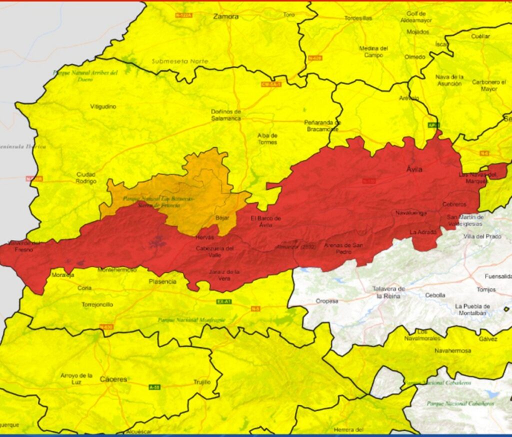
AEMET issues red alerts for Ávila and Cáceres as Storm Claudia triggers extreme rainfall and flood risks.
Credit : X – AEMET
@AEMET_Esp
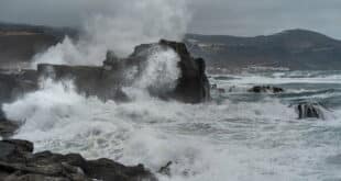
Spain woke to a dangerous cocktail of weather this Friday, November 14, as Storm Claudia swept across the country, unleashing torrential rain, powerful gusts and rapidly rising rivers – with the national weather agency AEMET issuing overnight red alerts for extreme rainfall in parts of Ávila and Cáceres.
AEMET red warnings overnight as rain turns “extraordinary”
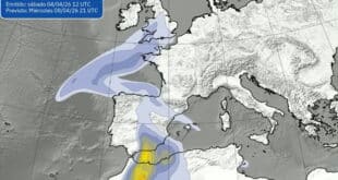
Through the small hours, AEMET activated red alerts – its highest warning level – for zones of northern Cáceres, the Central System and the south of Ávila, warning of the potential to exceed 120 litres per square metre in 12 hours. Authorities urged people to avoid riverbanks and flood-prone areas and to follow instructions from Protección Civil.
Those red alerts remained in force until 06:00 on Friday, November 14, but the agency cautioned that severe weather continues, with fresh warnings cascading across much of the peninsula as the system marches east.
Claudia’s signature so far: intense, persistent downpours under leaden skies, embedded thunderstorms in places, and rapid run-off sending smaller rivers and streams to the brim. Emergency services have been fielding calls for waterlogged roads, fallen branches and minor landslides, particularly across the north and interior.
Who is in the firing line today? Heavy rain, strong winds, sudden temperature drops
AEMET’s guidance for Friday points to widespread heavy rain in several hotspots: Andalusia, the Pyrenees, Galicia, the Cantabrian range and around the Alborán.
Wind will also play a starring role. Expect strong southerlies in the mountains of Mallorca, across central Spain and the northern half of the peninsula, as well as along the eastern Cantabrian coast and Atlantic shorelines. Exposed headlands could see severe gusts, making high-level routes and coastal travel tricky.
It won’t feel like yesterday either. Maximum temperatures are set to tumble, especially in the Pyrenees, eastern Andalusia and parts of Castilla-La Mancha, where the day will turn noticeably cooler under the rain and wind.
What does that mean on the ground? Road spray, sudden aquaplaning and poor visibility on the main corridors; localised flooding in the usual urban low spots; and, in the hills, crosswinds that can buffet high-sided vehicles. If you’re planning to travel, check your route, allow extra time and keep a close eye on AEMET’s live updates.
Practical advice: keep away from waterways and follow official guidance
With rivers already running high, Protección Civil’s message is straightforward:
- Stay clear of riverbeds, streams and low-lying crossings. A short burst of intense rain can turn a trickle into a flood in minutes.
- Don’t try to drive through standing water. Even shallow flows can hide potholes or sweep a car off course.
- Secure outdoor items (terrace furniture, plant pots, scaffolding) and avoid forest tracks or exposed ridgelines while the strongest gusts pass.
- Watch for falling branches in parks and along tree-lined avenues, particularly under those southerly gusts.
- If you live in a flood-sensitive area, move valuables off the floor and keep your phone charged in case warnings escalate.
AEMET will update or escalate alerts as new rain bands spin in around Claudia’s core. While the most intense burst triggered the overnight red warnings, the broader storm remains active, and the combination of saturated soils, more rain and gusty winds means the flood risk persists into the day.
Storm Claudia has put large swathes of Spain on notice. With extreme rain already recorded and further heavy showers and strong winds in the forecast, today is one to plan carefully, stay informed and keep clear of flood zones. We’ll bring updates as conditions evolve.