Costa News Spain Breaking News | English News in Spain.

As Storm Therese intensifies on Saturday, March 21, the Canary Islands have been under intense pressure. Snow at high altitudes, sudden flooding and dangerous coast surges are all conditions that the authorities have to deal with as a fast-moving and widespread weather situation affects multiple islands.
The immediate impact on residents and expats is the activation the PEIN emergency plans, which led to the closing of schools and the restriction of outdoor activities. Visitors and travellers to the islands also face major disruptions, as “Atlantic surge” forced the closures of high-risk routes and suspended many flight and ferry services.
Storm intensifies and more than 300 incidents have been reported
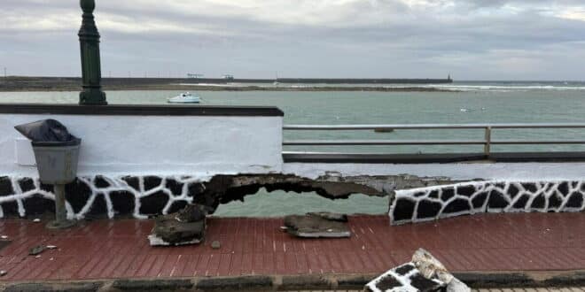
Emergency services have been stretched Since the storm hit the islands. According to Canary Islands 1-1-2 emergency coordination center, over 300 incidents related to Storm Therese have been recorded in a short amount of time. Around 200 incidents were reported by the Santa Cruz de Tenerife province, and around 100 in Las Palmas.
These incidents caused major disruptions, even though they were not life-threatening. There are reports of fallen trees, landslides and damaged street infrastructure. Also, there is flooding in urban areas, and problems with roads and public services.
Credit: Facebook/ Judith Dominique Wolfenegg
Severe weather across the islands
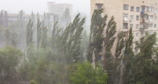
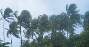
Storm Therese swept across the islands with a combination heavy rainfall, strong wind and rough seas. Authorities have warned that heavy rains and persistent drizzle are expected in many areas today. This will increase the risk of flash floods and landslides in mountainous regions.
In exposed areas, particularly at higher elevations, wind gusts exceeded 100 km/h, and coastal regions experienced dangerous sea conditions. Weather conditions in higher elevations have led to snowfall. This has made access to some areas more difficult.
How long will it last?
Initial forecasts indicated that storm Therese should begin to subside by Sunday. The updated forecast shows that storm Therese will begin to ease by Sunday. weather models now indicate In some places, severe weather conditions may persist through Monday or beyond. It is therefore possible that the disruption could last for a long time, especially in areas already affected by strong winds, heavy rain and rough seas. The authorities continue to closely monitor the situation as forecasts change.
What it means for your daily plans and movement right now
For the moment, it is likely that disruption will continue in parts of Canary Islands. This includes areas affected by heavy rain, strong winds and coastal conditions.
It is possible that road travel will be less reliable, particularly in mountainous regions or secondary routes where landslides and debris are more common. Travel times may be longer and certain routes may become unreachable without warning.
Access to areas such as hiking trails, higher altitudes, and natural areas is likely to be restricted during safety checks. Strong waves and unsteady conditions may prevent access to coastal zones. Flights and local services could be affected by delays or changes at the last minute, depending on what conditions develop in the next few days.
Authorities are actively managing incidents but risk prevention is the top priority. Normal activity has been put on hold. The most practical solution is to restrict travel to only essential trips, to stay informed via official channels and to plan with flexibility.
Visit our Spain weather page for the latest updates.