Costa News Spain Breaking News | English News in Spain.

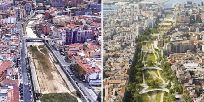
Before and after pictures of the Guadalmedina in Malaga.
Credit: Ayuntamiento de Málaga.
The proposal envisions a green and grand public space, five X shaped bridges and road-tunnels to hide the traffic.
The winning proposal was announced by Malaga’s local authorities on Thursday, August 14. This radical project is aimed at bridging a long-standing divide within the city. The plan, developed by engineering and architecture consultancy Esteyco, includes the creation of five “bridge-plazas”, the partial underground relocation of Fátima and La Rosaleda avenues, and a large green pedestrian corridor connecting the Armiñán and Perchel bridges. The plan, with a preliminary budget of €86.3 million, is a quest for urban connectivity while preserving the river’s hydraulic functionality.
Esteyco was awarded the €302,500 contract to draft the preliminary project for the bridge plazas, with a five-month timeline to finalise the design. The proposal includes innovative public spaces including five X shaped bridge-plazas that connect La Goleta to Santo Domingo. The structures will form green spaces, play areas, and recreational areas by connecting both riverbanks diagonally. The design ensures permeability along the riverbed by combining low water channels with green spaces and sports areas, without any fixed structures which could interfere with the river’s hydraulic performance.
The project also involves transforming Fátima and La Rosaleda avenues into pedestrian-friendly boulevards by partially burying their roadways. Other improvements include paving and tree planting along nearby streets like Pasillo de Santo Domingo or Pasillo de Santa Isabel. The actions aim to create a pedestrian-friendly green corridor that unifies the bridge plazas as well as boulevards and rivers.
“The river will always remain visible, ensuring permeability and safety,” said Penélope Gómez, Málaga’s Councillor for Environmental Sustainability.
The project aligns is in line with the ongoing Special Guadalmedina Plan and adheres to hydraulic studies conducted by Narval Ingeniería for Emasa and the Municipal Urban Planning Agency. These studies confirm that, during the flash floods of autumn, the riverbed is capable of handling up to 460 cubic metres per second. To optimise hydraulic capacity, the plan includes lowering the water level by adjusting the riverbed’s profile between the Armiñán and Aurora bridges, removing obstacles, and creating two hydraulic jumps to increase the riverbed’s slope.
Construction will be undertaken in five phases so as to ensure the feasibility of the project and its compatibility with riverbed lowering, road relocation and other factors. The ambitious project promises to reconnect Málaga’s riverbank neighbourhoods, creating a vibrant, green urban space for residents.