Costa News Spain Breaking News | English News in Spain.

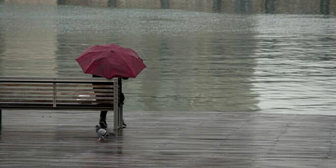
Showers sweep Catalonia as a DANA edges in — a soggy morning on Barcelona’s waterfront.
Credit: Michalakis Ppalis Shutterstock
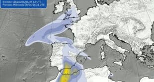
A fresh DANA – an upper-level low that often unleashes lively downpours – is lining up to break Spain’s record heat and drench Catalonia from Sunday, with showers spreading inland and a sharp dip in temperatures.
The INUNCAT plan for flood protection has already been activated by civil protection officials, who have warned of heavy rains, hail, and gusty wind.
Storm Timeline: Where and when it rains first
Sunday, august, 24 – midday onwards. Meteocat anticipates showers along the Barcelona and Girona coasts, and will then spread inland through Central Catalonia, Ponent, the west, and Pyrenees during the afternoon and night.
Flash-flood potential. In the eastern Pyrenees – notably Ripollès (Girona), Berguedà (Barcelona) and La Garrotxa (Girona) – downpours could top 20 litres per square metre in just 30 minutes, the classic recipe for sudden flooding on steep terrain.
National picture. AEMET reports that a cold front moves in from the northwest, while the DANA is spinning up over the southwest. This one-two promotes heavy and thunderous showers along the Catalan coastline, as well as the interior of the north-east, with a few thunderstorms brewing over the mountains to the south-east.
Morning setup. Before the break in the weather, the southern coastal strip has struggled to cool – lows of 24–25°C at 6am were logged – leaving juicy air in place for storms to feed on once the upper disturbance arrives.
The gear change: from record heat to storm risks
Hottest on record. AEMET confirms that Spain’s most recent heatwave is the most intense recorded. It beats out July 2022. On preliminary figures, the “heatwave anomaly” – how far maximums overshoot the threshold – hit +4.6°C.
What turns the switch? The air is destabilised by the DANA, while the Atlantic fronts add lift. After days of stifling heat (and torrents in Barcelonès and Maresme on Friday), the atmosphere is primed: brief but fierce cells are more likely than a gentle, all-day rain.
Temperatures tumble. As the storm system moves east, expect a cooling of temperatures, particularly in Catalonia.
Travel & safety: practical advice as INUNCAT goes live
Driving. Avoid underpasses, low crossings and ramblas which flood quickly. Slow down in the first few minutes of rain. Do not risk your life if the water is flowing.
Coast & mountains. Storms can be very violent. Watch the sky and leave the water when thunder is heard. Re-route your hikes to avoid narrow gullies or streams.
Hail & wind. Some cores can cause hail and squalls. Avoid parking under trees and secure terraces.
Stay informed. Check Meteocat and AEMET for live warnings and radar, follow Protecció Civil updates on #INUNCAT, and use 112 for emergencies.