Costa News Spain Breaking News | English News in Spain.

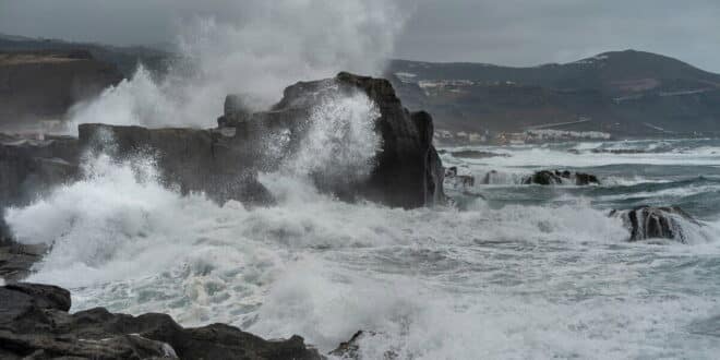
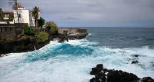
Canary Islands northern coasts have been hit with waves of up to 6 metres.
Credit: Shutterstock/Magui
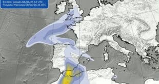
This Saturday, April 11th 2026, a polar mass of air and a following Atlantic front has triggered Orange or Yellow alerts in the Canary Islands. The AEMET warns that a powerful north-westerly swell The storm is creating waves of up to 6 metres high. It affects the northern coast of Lanzarote as well as the western slopes on Tenerife and La Palma. Wind gusts are expected to exceed 80 km/h in high-altitude zones, while temperatures have plummeted by 10°C, bringing rare April frost to the summits of Mount Teide. Prepare for possible maritime delays, and avoid coastal infrastructure. The surge in wave energy will make northern beaches and piers dangerous through Sunday.
Rain, winds and waves strike multiple islands at the same time
Storms are affecting multiple islands at the same time. Cloud cover is increasing, and rain will be expected in mountainous and northern areas. Forecasts indicate that rain is expected to fall throughout the day in Tenerife and La Palma, as well as on Gran Canaria and Lanzarote.
The wind is also a major factor. As the system passes through, the gusts intensify, particularly on high ground and along the coast. The sea condition is also deteriorating rapidly. Combined swell is expected to push waves beyond 3.5 metres, with peaks reaching up to 4–5 metres in some areas, particularly along northern and western coasts. This can lead to dangerous situations around the beaches, cliffs or ports.
Weather alerts raise risk in the Archipelago
The system is evolving and authorities have already issued warnings about coastal conditions, strong winds and other factors. Forecast models show the storm being driven by a low-pressure system in the Atlantic, which pulls unsteady air across the islands increasing wind and wave intensity.
Wind acceleration and waves impact are most likely to be stronger in areas higher up and along the northern coastline. Residents and visitors can expect conditions to change rapidly, even on the same island, depending on altitude, orientation and other factors.
What it means for tourists and residents
Canary Islands residents will likely notice the most impact along the coast. It is possible that strong waves and rough seas could restrict the access to certain beaches in particular, those located north. Maritime activities may also be affected. Wind gusts can disrupt outdoor plans on land, particularly in areas with elevated terrain or open terrain.
The rain is expected to come in intermittent showers, not constant. However, localised showers with heavier rainfall could occur, particularly on mountainous terrain. The key message for travellers is to be alert to any local updates. This is especially important when planning boat trips, excursions or coastal walks.
Return of a familiar pattern to the Islands
Canary Islands are accustomed to this type of weather, particularly in the transitional seasons. Atlantic systems move occasionally close enough to disrupt a mild climate. They bring short bursts in unstable weather, including wind, rainfall and rough waters.
Even though the current storm should pass, there are forecasts that indicate the conditions may remain unsettled in the short-term, with persistent wind and sea disturbances even after the rainfall has subsided. Currently, the main focus is safety, especially in areas exposed to coastal conditions where conditions are hazardous.