Costa News Spain Breaking News | English News in Spain.


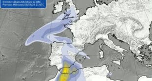
The sunny, warm weather of this past week in Spain is expected to end on Friday in the northern and eastern regions with locally heavy and localised rain.
The temperatures on Thursday reached 30C, which is similar to summer. There was just a small amount of rain in the northern parts.
The State Meteorological Agency(Aemet) is predicting ‘showers and storms from noon on Friday, especially in some inland areas, with a greater probability at higher levels’.
READ MORE

Ruben Del Campo, Aemet spokesperson said: “Between Saturday and Sunday, instability will increase. Showers will occur at points in the east and north of Spain. They could be very strong locally and even accompanied by hail.”
“Storms aren’t expected to hit the Mediterranean coast, but even if that happens, we will only be talking about isolated showers,” said he.
Castilla y Leon y Catalunya have been given the lowest yellow level for weather alerts due to storms that are expected on Friday.
Sevilla could be the first to reach 32C.
Del Campo says that temperatures are expected to fall across Spain, but especially in the north where they may drop by as much as 10C.
He said that in southern Andalucia temperatures would continue to rise and could exceed 30C in the Guadalquivir region, while some parts of Malaga province may reach 32C.
As for Sunday, Ruben del Campo said it was likely that stable weather ‘will return’.
The temperatures will continue to rise, even if there are showers in the Basque Country and other Mediterranean countries like Aragon, Catalunya, La Rioja, Navarre.
Next week, the high-pressure belt that brought us good weather could move away and be replaced by rain and colder temperatures.