Costa News Spain Breaking News | English News in Spain.


Spain’s state weather forecaster AEMET is issuing yellow warnings of storms, coastal gales, and hailstorms as it opens September.
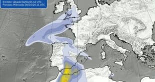
Today, the majority of the Peninsular and Balearics will be fresher. The Atlantic will bring more rain to the mid-week period.
Who’s on Alert and where the storms will land today?
The AEMET yellow warnings have been issued for the Balearics and north-east.
- Balearic Islands, showers and thunderstorms between midday and late afternoon. Some of these storms are briefly intense.
- Catalonia: Thunderstorms in the afternoon and evening. The Pyrenees, eastern counties and local downpours are flagged.
- Galicia spreading along the Cantabrian Coast: Rain bands arrive in the morning from the northwest and ripple eastwards.
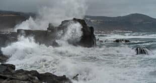
AEMET is also issuing yellow coastal wind alerts in Asturias (and the islands), Cantabria (and Galicia), the Basque Country (and the Balearics), and Galicia. These warnings include gusts of up to 70 km/hr on exposed coastlines. Expect the usual suspects on the wind map too: tramontana in Ampurdán and the islands, cierzo funnelling down the Ebro, and northerlies/westerlies elsewhere before easing round to easterlies along the Levante later. Early morning fog is likely to linger on the high ground of the north and Mallorca. It may also be stubborn in Galicia’s interior.
How far do temperatures fall?
Heat levels are dropping almost everywhere. No region is forecast to top 35°C this monday september 1; Alicante may brush that mark around the peak hours and Murcia sits near 34°C. Madrid and Barcelona stay below 30°C.
It’s a proper cool-air nibble in the interior of the eastern half, where night-time lows dip into single figures in spots of Aragón and Castilla y León — Burgos is the chilly pin-up at around 7°C. Not everyone is shivering, mind: along the Mediterranean fringe, minimums hold near or above 20°C, with Alicante and Murcia around 24°C.
The key takeaways in a glance
- Storm risk: North-east & Balearics; up to ~50 mm in an hour possible in Barcelona/Girona during the most active cells.
- Wind riskYellow coastal alerts for the Cantabrian arch and Balearics.
- Heat reliefThe South-East corner has no mid-30s, nor even 40s.
Spain weather: new Atlantic Front brings midweek rain, wind
This pattern will not disappear with the rain showers tonight. A front from the Atlantic will move into the northwest mid-week. It will thicken cloud in the upper-left quadrant, and push rain eastwards, possibly into Asturias. Temperatures tick up a touch on Tuesday, but forecasters still don’t see 35°C being breached, and Mediterranean nights remain sticky near 20°C.
September starts off on a brighter and more energetic note. Keep your brolly close by and be on the lookout for any lightning warnings if you are in Catalonia or Balearics. Be prepared for rougher seas along the Cantabrian or Galician coastlines. What if you live inland? Enjoy the break from the blowtorch — just don’t be surprised by a sharp, showery burst on the school run.