Costa News Spain Breaking News | English News in Spain.


AEMET warns rain and dropping temperatures in Spain as it expects snow to fall higher up.
Credit: Shutterstock/Leica dream
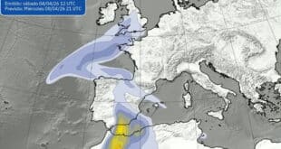
AEMET has activated Yellow Alerts Snow and heavy rain are expected to begin this Saturday, 11 April 2026 as a cold air mass collides high spring humidity. Forecasts predict that snow levels will drop to 600 meters at Soria and the Cantabrian Mountains, with accumulations of more than 5cm by Sunday morning. In the south and east, “mud rain” is expected due to a mixture of thunderstorms and a layer of dust suspended in the air (calima). Travelers in the Valencian Community should be prepared for flooding and hazardous conditions at high altitudes. The saturated ground of previous weeks is a major factor that increases the likelihood of surface water building up quickly during heavy downpours.
Rain falls in the eastern and southern regions
AEMET forecasts widespread rain in eastern mainland areas. This includes the Valencian Community and parts of Andalusia. Storms are also expected to develop in inland regions.
There will be heavy rain at times. These short, intense bursts could overwhelm drainage systems and cause localised flooding. Conditions could become rough along the coast, as stronger winds and unsteady waves affect small vessels and shorelines exposed to the elements. The unevenness of this system makes it more difficult to handle. It is possible to have brief showers in some places, but persistent rain could last for hours.
Snow on the higher ground
In addition to the rain, temperatures will drop in high inland regions, bringing back snowfall to mountainous areas. AEMET says that snow may fall at relatively moderate altitudes this time of the year, especially in northern and central interior.
It may also affect routes and mountain roads that have been weakened by recent weather. Snowfall will be moderate, but it is still a danger for those who travel in high places and drivers. Snowfall so late in the spring season is a reflection of the ongoing instability in Spain’s weather pattern where cold and warm air masses are still fighting for dominance.
This weekend might feel different
Spain has experienced several bouts of unsettling weather over the past few weeks. However, the current situation is unique because it combines rain, storms, and snow at the same moment.
In some areas, the soil is already saturated and this increases the chances of surface water accumulating quickly. In these conditions, even moderate rainfall can cause disruption. Timing is also important. As more people travel and spend time outdoors in summer, even short-lived conditions can have a greater impact.
What it means for travel plans and daily life
Drivers will be most concerned about rapidly changing weather conditions. During heavy rain, roads can become hazardous in minutes. This is especially true on secondary routes. Snowfall in mountainous regions can cause temporary or slower travel times, depending on the conditions.
Most air travel will continue as usual, but there may be some delays if storms intensify around major airports. Anyone who has outdoor plans for this weekend might need to change their plans quickly. Conditions will vary, not only between regions but also within each region.
What to watch this week
AEMET will continue to closely monitor the system, and new data may lead to forecasts being updated. According to the current forecast, instability could continue into next week’s first few days before it gradually eases. The spring of this year has already demonstrated that weather patterns are unpredictable and can be quickly changed.