Costa News Spain Breaking News | English News in Spain.


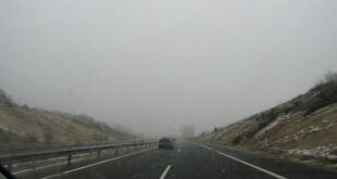
Severe weather hits Andalucía as multiple alerts remain in place.
Credit : Sergii_Petruk, Shutterstock
Andalucía is bracing itself for a rough day of weather this Wednesday, January 28 , with powerful winds, heavy rain and dangerous sea conditions forecast across much of the region.
The situation is particularly serious in Almería, where authorities have activated a red weather warning Extreme gusts of wind could reach 130 km/h. Other parts of the region are still under orange alerts with disruptive conditions from early evening to late night.
Almería on red alert as extreme winds take centre stage
Almería faces the most severe conditions. In areas such as Valle del Almanzora and Los Vélez, violent easterly winds are expected between 9am and 9pm, with gusts potentially peaking at 130 km/h. After the red alert has been lifted, the strong winds will continue through the night with orange warnings.
Other parts of the province, including Poniente, Almería city, Levante and Campo de Tabernas, will also be hit by very strong westerly winds, frequently exceeding 90 km/h and, in some places, climbing well above 100 km/h.
The conditions on the seashore will also be hostile. Orange coastal warnings continue to be in place all day with waves and rough seas of up four metres.
Heavy rain and coastal warnings for Cádiz and Málaga
While wind remains the dominant factor across Andalucía, rainfall is set to cause additional problems, particularly in Cádiz and Málaga, where orange warnings are also active.
In Cádiz, the Grazalema area is expected to receive intense rainfall, with up to 100 litres per square metre in 12 hours, and even higher totals possible in isolated spots. Winds will blow strongly in inland areas and along the coast, including the Strait of Gibraltar. Local gusts of 110 km/h are expected.
Málaga will see the heaviest rain around Ronda, where persistent downpours could lead to significant accumulations throughout the day. Sol and Guadalhorce will also see strong winds, and both the eastern and western coasts remain on orange alert for rough seas with waves up to four metres.
Expect widespread disruption across the region
Storm impact will extend beyond eastern provinces. Córdoba, Sevilla, Huelva, Granada and Jaén are all under a combination of orange and yellow warnings for strong winds, heavy showers and hazardous sea conditions.
In Granada gusts up to 120 km/h can be expected in inland regions such as Guadix or Baza. The coast is also subject to waves up to 6 metres high. Jaén will also experience strong winds throughout the day, particularly in Cazorla, Segura and the Guadalquivir valley, alongside periods of heavy rain.
Authorities urge residents to stay away from coastal areas and avoid travel that is unnecessary. They also advise them to secure outdoor items.
With multiple alerts active at the same time, Wednesday is shaping up to be one of the most disruptive weather days of the winter so far in Andalucía.