Costa News Spain Breaking News | English News in Spain.

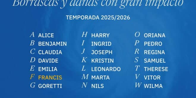
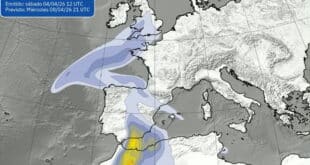
Storm Francis is officially named by Aemet as part of the 2025–2026 Atlantic storm season.
Credit : X – Aemet
Spain’s calm after heavy rain and disruption is beginning to appear deceptive. Although the weather may seem calmer, the sky is clearer, and the air cooler, it’s not going to last.
The Spanish weather agency has confirmed the forecast. AemetA new Atlantic storm, named Francis, is expected to arrive around New Year’s Day. It will bring a fresh round rain, strong wind and drastically changing weather conditions. While the worst is not expected to happen immediately, it could not be more convenient.
New Year’s Eve, in Spain, is more than just a date. The night is filled with family reunions, long dinners and late travel. As it is often the case, the weather will soon be influencing the plans.
From floods to frost – a sharp change of mood
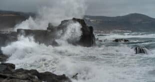
It has been shown in the last few days how quickly weather conditions can change. The weekend rains in Spain left behind floods and emergency calls.
Nearly 180 litres of rain per square metre fell in Carcaixent (Valencia), with most of it falling within six hours. Abanilla in Murcia recorded 85 litres of rain, the majority in just one hour. Meanwhile, Marbella recorded 77 litres in less than six hours – the kind of concentrated rainfall that overwhelms drainage systems almost instantly.
The weather changed abruptly.
Since Tuesday, December 30th, a strong anticyclone settled over most of the country. This brought clearer skies, and a dramatic drop in temperatures at night. Aemet says that the quieter phase should last until Friday. This will be marked by sun, stability, and frost throughout the country.
Clear skies allow heat to escape overnight. This has resulted in a cold start for many parts of the interior. There has been frost in mountainous regions and on the northern and middle plateau.
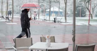
Fog, ice, and other driving conditions that are difficult
With calm winds and cold air trapped near the ground, dense fog has been forming across inland regions, particularly in Castile and León, parts of Galicia, and the northern plateau. The fog in some areas has been slow, lasting well into daylight.
In cities like Zamora, Palencia and Valladolid, temperatures have struggled to climb much above 5°C, with fog keeping conditions grey, cold and damp. When temperatures drop below freezing, ice patches can form on the roads, particularly at dawn.
Already, traffic authorities are warning drivers that they should be extra careful during the busy New Year period. Low visibility, black ice or freezing fog can make routine trips very dangerous.
Storm Francis is waiting for its turn
As the sun shines in Spain, our attention now turns west. Aemet predicts that Storm Francis, a low-pressure system in the Atlantic, will reach the Canary Islands by Thursday.
After several days of relative calm, rain is expected to fall across the islands. This could be heavy and persistent locally, especially in Santa Cruz de Tenerife. This is the start of a wider change in weather patterns.
Francis, in contrast to the current cold air, will pull in milder Atlantic wind, causing temperatures to rise and frost conditions on most of the country. Snowfall will largely be restricted to the higher mountainous areas and widespread freezing should retreat.
But milder doesn’t mean quieter.
The New Year is greeted by rain, wind and uncertainty
As the New Year begins, the storm is expected to move eastwards and send successive weather fronts through Spain. Cloud cover will increase in many parts of Spain from Friday, and mists and fogs are expected to form in the mornings over the inland areas, before clearing later in the day.
Despite the arrival of milder air, Aemet warns that New Year’s Eve and New Year’s Day could still bring below-average temperatures in some interior areas, with overnight lows dropping close to -5°C in places like Soria.
Francis will likely cross the Iberian Peninsula by Friday or into the weekend. Meteorologists have been watching Francis closely because it could create a volatile combination: warm subtropical and cold polar air masses.
The combination of rain and snow has caused significant episodes in the recent past. At this point, forecasters are hesitant to rule out anything.
Samuel Biener, a weather analyst in the Canary Islands, has warned that areas exposed to rain could receive more than 50 litres of rainfall per square metre on New Year’s Day. There are also strong winds, with gusts reaching up to 70 km/hr in some places.
It’s still too early to be sure
Forecasters insist that there’s still uncertainty, despite warnings. The storm’s course could be altered by small changes, which would affect the intensity of the wind and the location where the most rain will fall. It is also possible that temperatures will drop again early next week.
Some models predict that the cold air will return around Monday 5th January, increasing the possibility of snow at lower altitudes right before Three Kings’ Day. Three Kings’ Day is a holiday that sees a lot of travel in Spain.
For the moment, meteorologists are warning people to be cautious and not alarmist. Be prepared to adjust your plans if necessary.
The weather is set to remind us who is really in control as Spain prepares to bid 2025 goodbye.